What I saw was beyond description – as were the emotions that flooded me as I stood in the howling wind that raced through the narrow corridor... I now felt that this was a land far more impressive than I had been led to believe, and one that surely held many valuable secrets. Here in Mustang, I now felt, existed a world even older than Tibet... I had found this closed universe, and the mythical fortress of a lost planet; for there a lunar landscape of barren crests, with jagged contours, stood, serene, majestic, and awe-inspiring the great mass of a fortified town.” (Michel Peissel 1967)
Although any academic may be easily vexed by the exaggerated romantic tones of upper Mustang's narrative descriptions, for anyone who has experienced its landscape, it is obvious where such poetics emanate from. Traditionally known as Lo, Mustang lies in the trans-Himalayan portion of the upper Kali Gandaki valley in northwestern Nepal. Geographically, the Annapurna and Dhaulagiri mountain ranges separate this area from the cis-Himalayan mountain regions of Nepal. The upper Lo (upper Mustang) region covers an area of approximately 780 square miles that comprises mostly of arid, mountain deserts that are cut at steep angles by fast flowing mountain-rivers. Historically from the 15th to the early 20th century this entire area was a vibrant trading route between the various kingdoms of pre-unified Nepal (later the Kingdom of Nepal), India and Tibet. Although the history of peoples of this region goes back to pre-historic times, upper Mustang has existed as an identifiable entity from at least the 7th century AD. Upper Mustang has also been a very important hub for, firstly, the Bön religion and, later, Tibetan Buddhism. This region is inhabited by the Lo-pa, a people culturally, linguistically, and ethnically similar to those of neighboring Tibet.
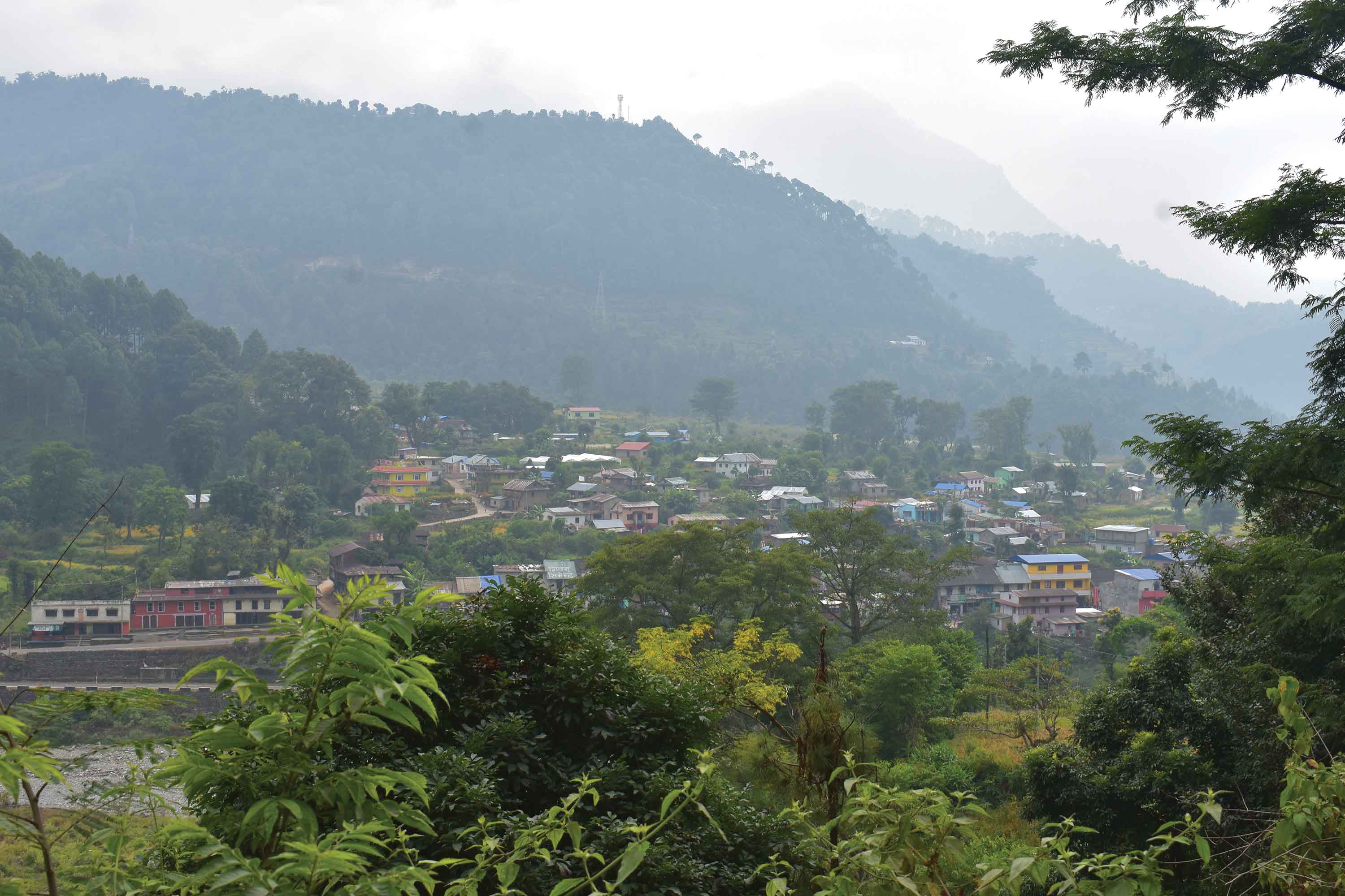
Due to its remote geographical location and the absence of natural resources, upper Mustang remained in a shadow until 1992 when it was first opened up for tourism. Now having emerged from its historical cocoon of cultural and economic isolation, the region has not only been exposed to tourism but also to many internal stimuli that are continuously transforming its cultural and economic landscape, perhaps irreversibly. Having been described as a timeless place, a place that somehow escaped the engagements of the industrial revolution, a place where the peoples still nurture a close relationship with the land, a place that is both pristine, primitive and thus beautiful, upper Mustang has been overly mystified in one too many travel journals. Can a place like this really exist? Upper Mustang has surfaced today out of a particularly rich cultural history into a world that induces rapid transformations, promotes particular doctrines of progress, and is comparatively more outward looking than introspective. To add to this modern flux, a motor able road is being built that aims to connect the upper recesses of Mustang to the lower hills of Nepal. Jomsom is now connected to Beni by a three to four-hour jeep ride. Muktinath is connected to Jomsom and Kagbeni by similar roads. The construction that is happening simultaneously from opposite ends has reached the villages of Gelung and Ghami respectively. This new road is a brand-new addition to upper Mustang's cultural, economical, and natural landscape.
Egged on by a German
I was in the Gosaikunda area when I first heard about the pristine nature of upper Mustang's landscape from a German traveler. I had visited lower Mustang District up to Muktinath with my father some 12 years earlier. Using that as my reference point, I was initially disappointed that this untouched area now subject to the will of dynamites and bulldozers, would somehow lose its natural beauty and transform into some place undesirable. Travelers can be very selfish and marginally narrow-minded in their opinions of development of infrastructure in remote, previously undeveloped areas. My own disappointment, however, quickly gave way to an intense curiosity that later ushered me to the area to witness the building of the road, and secretly, also to consume the raw landscape before it is tamed by construction. Upper Mustang, the subject of so many mystified fables, would once again emerge as a real place. How will the road transform upper Mustang?
Tourism in upper Mustang has specific implications. Since the disruption of the traditional trading route with Tibet, it was economically confined to subsistence agriculture and animal husbandry. Individuals from most households also migrated either to India, Kathmandu, Pokhara, and other mid and lower hill areas for employment to make up for the lost trades with Tibet. Moreover, since the opening up of the region for tourism since 1992, this region has witnessed considerable economic stimuli. Just as traditional trade had provided for the peoples of the region, tourism promised similar economic opportunities. Tourism here has so far been restricted to trekking and camping. Before the road that connects Beni to Jomsom was built, the trek towards upper Mustang had three popular starting points. One was from Beni, in Myagdi District, after a bus or taxi ride from Pokhara. There was also the option of starting from Nayapul, a small roadside settlement on the Pokhara-Baglung-Beni road. And although tourists also have the option to fly straight from Pokhara into Jomsom (the third option), the unpredictable mountain weather conditions often renders it simpler to walk in. Along the entire length of the tourist trails lodges, restaurants and hotels sprang up at regular intervals, providing valuable business opportunities for the people living along the route.
I wondered how the building of the new road will affect these people's chances of harnessing an income out of tourism in the area.
Let's get on the road
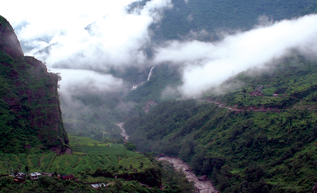
My own journey started in Kathmandu, accompanied by my childhood friend, Parash, a doctor. Being quite obstinate about using only local transports, we took a bus to Pokhara and on the next day to Beni. From Beni we boarded a small bus that took us to Jomsom. The road to Jomsom had only recently been carved out of the hills and was very rudimentary and, at times, extremely scary if not downright dangerous. Enroute to Jomsom, we passed through Galeshwor, Ghasa, Marpha, and Tukche. Several times the bus came so close to the edge of the road that a precipitous drop into the Kali Gandaki seemed imminent. The drop-offs into the river beneath us were frighteningly steep at times. Having found a comfortable perch on the roof of the bus, however, I had little time to worry about calamities. Though dangerous, the ride was incredibly scenic. With the recent rains, the hills were happily clad in shades of green and majestic waterfalls adorned several rocky crevices. Huge eagles soared the skies as I wondered how the land might look from their eyes.
From the lower forested hills and along the enormous Kali Gandaki River we climbed steadily towards the Tibetan plateau. As our bus blew clouds of dust into the houses adjacent to the road at Ghasa, I wondered if operating hotels and lodges there was still lucrative. Since the construction of the road between Beni and Jomsom, the little settlements along the way, like Ghasa, have become bereft of tourism. The shrinking of the journey to Jomsom and upper Mustang means that any typical tourist will spend less of their money along the way. Consequentially, many places are now deprived of the economic benefits from tourism that they previously survived on. Tourism will predictably be concentrated in fewer hubs like Marpha and Jomsom. It is unlikely these hubs will be adversely affected, but for smaller places like Ghasa and Lete the new road certainly means fewer tourists and lesser incomes.
Shall we now walk?
We arrived in Jomsom at dusk and were greeted by the stoic Nilgiri Mountains. The fresh mountain air summoned a demanding appetite and over dinner at Hotel Lali Guras (it means 'rhododendron' in Nepali) close to the Jomsom airport, I asked our hostess about her opinions on the new road. According to her the road will, as predicted, bring much prosperity to Jomsom. I had already noticed a marked transformation in the architectural styles of the houses, from my memories of Jomsom 12 years before. Apart from foreign trekkers, Jomsom will also welcome religious pilgrims who can now make the journey to Muktinath without having to walk the arduous mountain trails. Business in Jomsom will continue to rise as the new road nears completion.
The next day we woke up bright and early with the intention of starting our trek towards Lo Manthang - the old cultural capital of Mustang. As we crossed the bridge over the Kali Gandaki and moved away from Jomsom, we had to walk on the new road towards Kagbeni. In the belief that our trek had finally begun, we refused to flag down the first jeep that passed us by. In return for our polite turndown the jeep enveloped us in a suffocating cloud of dust and rudely turned the landscape murky. It seemed to make no sense to walk the dusty road while we could just as easily catch a ride. The jeep-ride lasted about 30 minutes. From Kagbeni our trek would begin. As we left Kagbeni we came across a bulldozer lodged uncomfortably on our trail. Sitting awkwardly on the narrow sandy track, the bulldozer marked the frontier of the road construction. As the dozer nonchalantly moved the loose mountain soils against the splendor of the landscape in the background, I had a profound epiphany. This was it - Us, people transforming the land. What had taken the earth countless millennia to create will take the dozer no time at all to demolish. The road will be built. The land will be transformed.
Almost simultaneously with the road, electricity is also scheduled to travel up to upper Mustang. Roads and electricity - the two pillars of modern progress are now on Mustang's doorstep. A ways farther along from the first callous dozer at work we came across a second dozer that had stopped working and was temporarily abandoned on the mountain path. Was it the earth fighting back? Resisting change?
The trail took us along the upper Kali Gandaki River, which by now had spread wide and thin across the great valley that connects Kagbeni to Chhusang. We learned that during the dry season it is possible for tractors to navigate a considerable length of the river, the natural road, all the way to Ghelung. This, however, was the rainy season, when the river dictates matters differently. Soon after we crossed Kagbeni, the motorable section ended. From here on there would be only legs and mules.
Into the restricted area
It is only after crossing Kagbeni that one enters the restricted area of upper Mustang. For foreign travelers it costs a staggering $500 for a 10-day permit. (For Nepalese it is complimentary.) After Kagbeni came the rustic village of Tangbe. The walk from Tangbe to Chhusang was along an undulating trail that sometimes lowered us to the banks of the river. The dramatically rugged mountains that formed the walls of this valley gave the impression of being sculpted by skilled hands. The shades of the rocks oscillated between rust-brown and pale yellow. adding to the splendor of this theatrical landscape. About noon, though, the famous Mustang winds started picking up and from then on the wind relentlessly howled into our ears every day from noon until early evening.
From Chhusang onwards we left the easy river valley and started our first real uphill. The landscape is so unkempt and rugged here that I wonder how in the world a road will be built here? Having conditioned our bodies earlier by trekking the Helambu/Langtang circuit, we strolled on merrily uphill. Along this part of the trail we befriended a girl 21 and her brother 14, on their way home from Pokhara to Ghelung. She had recently completed her high school examinations in Kathmandu, and he was returning home from a monastic school (to become a lama) in Dehradun, India. The girl told us it had been 12 years since she last visited her home village.
How would I feel if I had to walk three arduous days over challenging mountain terrain just to get home? So would it be fair to these kids to denounce the road as an unnecessary evil that adversely affects tourism? What about the people here? Would the children not have been happy had the road already been completed and their three-day trek reduced to a few hours bus ride? In the absence of alternate modes of transportation, the new road does not seem entirely disagreeable. Should areas like upper Mustang be preserved in their supposedly pristine state for tourism or are there other important accounts to be taken into consideration?
Previously, before setting out on this journey, I heard numerous complaints by tourists about how the new road will destroy upper Mustang and how its untouched value will be irretrievably lost. This myopia, symptomatic of tourism industries worldwide, arises out of a belief that exotic places must be frozen in time, secured against the modern forces of change, and preserved so that tourists and trekkers can imbibe in the anachronism that is thus created. This belief fails to acknowledge that places and cultures are not static but are enmeshed in a dynamic flux where changes and transformations are a part of a place and peoples' natural and cultural histories. Much before it became a tourist attraction, Mustang too, was already a vibrant cultural and economic center. Taking into account the history of the place and closely examining the smaller, subtler transformations that the place has experienced, it would be hypocritical to consider the new road as incongruous with Mustang's past. On the contrary, given the history of trade with Tibet and India, and considering Mustang as the gateway of Buddhism into Tibet, it seems logical to imagine a functioning road that connects Mustang to the lower hills and cities. It is only against an informed background that this new road appears contiguous with Mustang's history.
Of mules and locomotion
Our rest stop in Chele proved to be quite rewarding. It's a small village of stone houses built closely together. On the door to the first house in the village hung an enormous skeletal head of a yak. The local people believe that evil spirits can be kept at bay this way. The water that flowed through a pipe in the centre of the village was refreshingly cold and delicious. The meal of rice, dal (lentils), potatoes, and achar (pickle) was simple but very palatable. This was to be our fixed menu for the rest of our time in upper Mustang.
The expressive rocks on the hills and mountains around us posed elegantly in the changing light. These rocks have a remarkable ability to change colors with the light. As the sun played amongst scattered clouds, the landscape too seemed to dance in colors. Amid the pale desert colors, the village of Ghyakar was an oasis of bright spring greens. It was barley-planting season and the young sprouts decorated the village fields in such hues that even our tired soles found momentary relief in this delightful distraction. The enormity of the ravishing Nilgiri and Tilichho peaks to the east and the Dhaulagiri and Tukche to the west is humbling. The snow-clad grandiosity of these mountains is unmatched. The cobalt blue skies of Mustang provide a perfect backdrop and render a startling crispness to the scenery. The serenity of this landscape invokes poetry and with every step it seemed as if we were heading towards an ancient, uncharted land.
Our path was becoming progressively more challenging. The drop-offs from the trail were getting staggeringly dizzying. The trail itself is an ancient conglomeration of dirt, rocks and mule-dung. Although the paths are, for the most part, well maintained, there are numerous places where one has to walk very cautiously. The jagged stones and pebbles that continually poke at one's soles present an enduring challenge. Every now and then the pungent stench of mule-piss drill the olfactory senses with vengeful fervor. Flies, once disturbed from their mule-dung, buzz around angrily as if in retribution for our encroachment. As the day slipped into early evening, our backpacks tugged harder at our shoulders. By now the trail had wrapped itself around the side off a rocky hill as we headed north quite steeply towards Samar.
As it was the off-season, we hardly came across other travelers. Of course there was the occasional mule caravan carrying supplies up. How much longer before the mules would be relinquished from their mountain ordeals? Along the trail we learned that as the road was getting closer to completion many people from the upper Mustang region were selling their mules and horses to others in the Dolpo region. These animals, which have been a part of the cultural landscape for such a long time, will finally be ousted to make room for the machines of locomotion.
Passes and determination
We arrived at Samar towards evening, though in order to reach it one has to climb a hill overlooking the village. Samar was the greenest village so far. Barley-planting season meant that the fields were freshly green with young sprouts. Considering the lifeless rocky landscape, the luscious greens of the village seemed particularly welcoming. We were too tired that evening, however, to marvel at the beauty of the place. In Samar we came across two gentlemen from the Village Development Committee in Jomsom. They were on a project to evaluate Ghami khola (river) for a potential hydro-electricity project that could possibly produce electricity for the entire Mustang district if completed. These gentlemen expounded on the challenges to their project as we dined on our regular meal of rice, dal, and potatoes. Several Buddhist monks were also present in the hotel. To complement our meal, the lady of the hotel had given us each a few pieces of dried goat meat that we chewed guiltily in the monks' presence.
The next day's journey involved crossing a couple of hard passes before we reached Syangboche. Passes characteristically test one's endurance and determination. Crossing one usually involves a steep climb to the top of a hill or mountain followed by a rapid decent to lower altitude. Bhena La, a pass (la) of 3860 m, was our first hurdle. Though not particularly difficult, it was the persistence of the uphill climb made it exhausting. No matter the state of one's physical condition, people face their own particular set of challenges on a pass. The thin atmosphere, gasping lungs and cramping muscles must be overcome by sheer determination.
Upon climbing Bhena La, both Parash and I felt a great sense of accomplishment. It was windy on the top and our sweat-drenched bodies chilled rapidly in the gusty mountain gales. The endless sea of rocky desert mountains continued as far north and east and west as far as the eye could see. Was this the middle of nowhere? It was only towards early afternoon that we made it over the Beg La and Yamda La passes before descending into Syangboche. Syangboche, contrary to all our imaginations, was just a couple of newly built stone houses alongside the trail.
After the mountain passes it would be mostly downhill all the way to Gelung. The hill before one arrives at Gelung provides a nice vantage point. The houses are built in the traditional style where stonewalls define the square perimeter. Wooden logs serve as supporting beams and also buttress the roof that is built entirely of mud. Dried twigs and branches are placed along the perimeter of the roofs giving the houses a boyish kind of a hairstyle. These dried twigs form an overhang on the roof that is reminiscent of overgrown sideburns begging for a visit to the barber's. The overall aesthetic effect of these elements put together is one of archaic, rustic simplicity. The Gelung houses were built close to one another giving the village an intimate atmosphere. Here too we ate rice, dal, and potatoes. Despite the monotony of our meals, our appetites only grew surprisingly larger as we walked further into upper Mustang.
Where is Lo Manthang?
From Gelung our plans would take us all the way to Ghami, the second biggest village of the region. Immediately upon leaving Gelung we were once again confronted by the road. This was the lower portion of the road being constructed southwards from Lo Manthang. This road in Gelung was its upper counterpart. Motor roads are usually zigzagged and present a longer distance to walk. In most places with new motor roads, the old foot-trails also still exist as if in denial of their imminent disuse. Foot-trails are steeper and thus cover walking distances much quicker. From Gelung the foot-trail was mostly uphill. Very soon we were confronted with the Nyi La pass at 4010 m. From the top of Nyi La, which was windy enough to knock one off-balance, the panoramic vista revealed yet more layers of rocky-mountains in all directions. Later in the afternoon we had to cross the Ghemi La pass at 4065 m before descending towards Ghami.
Our destination was Lo Manthang. The walled-city had already managed to wrap itself in a mysterious veil. From one traveler we heard that there are so many cattle there that it takes almost three hours for all of them to pass through the city gates after each day of grazing. From another we heard of ancient gompas (Buddhist temples) in the town. Another told us about the caves at Chhoser, close to Lo Manthang. Lo Manthang the medieval city. Lo Manthang the old capital of Mustang. Lo Manthang the place of the palace and royalty...
The caves in Chhoser date back at least 2,500 years. They have been carved out of a rock-face hollowed out from the inside to create intricate corridors and numerous separate rooms and compartments. The Jhong Cave in particular holds much historical importance. It alone has more than 40 rooms! There are stairways that lead up to the fifth storey and each storey has its own floor plan of rooms and corridors. The ceiling of these caves has turned jet black with the smoke from the fires that people used. It is hard to imagine how the engineering so long ago was sufficient to build such a massive structure. As the story goes, local villagers used these caves for shelter from bandits.
Once when Hajigava, a Tibetan terrorist Gang, attacked the village the locals escaped and barricaded themselves in these caves. The terrorists then cut off the water supply to the cave thinking it would force the villagers out. One evening, the witty villagers put their heads out the windows and washed their hair with mustard oil. The bandits, mistaking the mustard oil for water, were tricked into thinking that the villagers had plenty to drink in the cave, lost hope, and went away empty-handed.
Stampeding dzum and dzopkyo
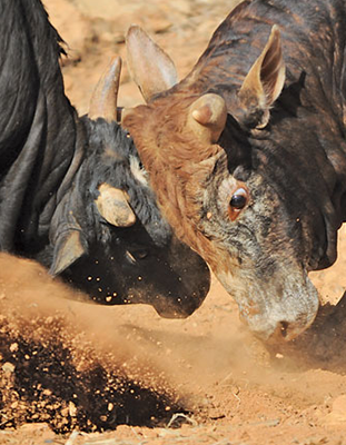
When we arrived in Ghami the warm evening light was painting the village in welcoming colors. It was the time for cattle to be herded back into their sheds. That's when we witnessed a strange commotion. Apparently a herd of cattle had run amok on someone's grain-field and the shepherds, somewhat perplexed and noticeably irritated, were hastily herding the cattle back into the village. The result was a brief chaos. Out of nowhere came the cattle, first one then another until it became a massive flow of beasts, black and grey bodies rushing pell-mell down the narrow alleyway. These cattle are a crossbreed of yaks, cows, and lang. A lang is a cross between either a yak or a nak (female yak) and local cows or Tibetan bulls. The physical build of dzopkyo and dzum is between that of a cow and a yak, quite robust and beastly. As these cattle swarmed the alleys, they kicked up dust giving the scene a mysterious Western hue. The clanking of their horns, the stomping of their hoofs, and their snorting filled the air with a riotous uproar. We had no idea what was happening and literally jumped up a set of stairs to get out of the stampede's way. Chaotic and exciting!
Upon entering, Ghami feels like a populous town. The whitewashed stone houses are built close to one another forming quaint, narrow alleys. A water drain runs the length of the main street through the entire village. A cobbled street leads one right to the heart of the town. Upon learning that there were no vacant rooms in the only hotel, we decided to sleep out in the campground. Luckily I had brought my tent along and despite the initial disappointment, we felt privileged to rest under the stars. After another meal of ever-so-appetizing rice, dal, and potatoes at the hotel we happily lit a small fire, set up our tent, and readied ourselves for the next day's journey.
Television anyone?
Soon after we crossed the Ghami khola the next morning we came across a long mani (prayer) wall, the longest and most spectacular in Nepal! Built entirely of local rocks and dirt, the mani wall sports the same colors as the surrounding mountains. Next to the mani wall is a hospital built by a Japanese project. The rocks and mountains seemed to have more folds here than at other places. The colors on the rocks were also more vibrant hues of reds and yellows. The vastness of the cobalt skies could only be matched by the immensity of the mountain landscape. Fueled by the exhilaration of arriving at Lo Manthang and nudged along by the splendor of our surroundings, we arrived at Tsarang at lunchtime.
The village of Tsarang is unique because the houses here scattered and far apart. Large barley fields separate these scattered houses. It is only in the old part of the village that houses are clustered close together. Tsarang also holds great historical importance. The Tsarang Molla (an historical document) has played a pivotal role in compilation of the history of the entire Mustang region. Tibetan Buddhism is believed to have flourished in Mustang from the 14th century Tsarang monastery. The Samdub Ghephel Palace, a five-storied structure located on the rocky hill close to the monastery, too, holds considerable historical importance. This palace housed one of the greatest libraries in Mustang and still contains an impressive collection of sacred texts.
We decided to have fried potatoes and noodles for lunch, thereby adding a little variety to our otherwise rigid gastronomic experience of Mustang. From the roof of the hotel we looked out at the surrounding landscape with both pride and humility. Around the village were also several big television satellite dishes that promised numerous channels on the TV. When did satellite television reach Tsarang? The modern satellite dishes when juxtaposed with the medieval chortens and palaces presented a rather baffling picture. Some processes of transformation are subtler than others.
Towards the capital
As promised, the last day on the trail to Lo Manthang was relatively easier. After Tsarang, the skies got muddy and lightening streaked behind dark clouds. Gray clouds from the west were threateningly marching eastward, encroaching on blue's territory. There was electricity in the air and a certain restlessness could be sensed even among the sessile rocks. Energized by the atmosphere we walked on towards our destination. The landscape had opened up a bit and we were now walking on a wide mountain plateau. The trail, too, was wider - or was it the road? - and held signs of frequent use and even sported tractor treads.
In the excitement of arriving at our destination, the Lo La pass did not seem so taxing. From there we made a short rendezvous to a chorten that overlooks Lo Manthang. The high point of the chorten allowed us to study the town as one would read a map. Compared to other towns and villages we had seen along the way, Lo Manthang was huge. It is situated on an immense mountain plateau that stretches from the west to the east. The town itself is placed in the centre of the plateau, next to the cliffs of the Chhyoro Dhokpo khola. A stonewall demarks the perimeter of the town. This wall is 2,472 ft long, 26 ft high and has a series of 14 towers along its periphery.
The next prominent feature is the royal palace, an immense four-storey structure in the center of the town. The Thupchen Gompa, the second oldest Gompa of the town, is also imposing. It was built in the early 15th century by Tashi Gon, the third Raja of Mustang. Painted almost entirely in red this Gompa lies to the northwest of the palace and houses a massive assembly hall. The Jhampa Gompa (or Jampa Lhakhang), is another massive red structure, and is Lo Manthang's oldest gompa. Built in 1387 AD during the reign of the famous king Anguin Sangbo, this gompa is north of the palace. And, farther north, across the river, the village of Namgyal appears lonely on an immense landscape.
Loitering in Lo Manthang
Since the only entrance to the town was in the northeastern corner, we had to walk around the wall to a huge wooden gate. Our hearts pounded with excitement as we walked towards the center of the town. The whitewashed, stone houses of Lo Manthang are built close to one another. It seems as if the entire town was built around the palace. The outer streets are wide and cobbled. Several villagers were strolling along this street as we checked into Hotel Mystique, one of the three hotels operating here. Despite our exhaustion, we could not resist going on a short walk. The inner streets are considerably narrower and the houses alongside stand shoulder to shoulder. There was much activity on the streets and villagers walked to and fro with an air of patient deliberation. As we approached the palace we were once again astounded by the enormity of its white walls. A gigantic Tibetan mastiff dozed lazily in the palace periphery. As we passed through the gate that leads to the inner city, a large herd of goats swarmed the streets. Unlike the larger dzopkyo in Ghami, these goats posed no threat whatsoever.
There were numerous shops around the palace selling everyday goods. Straying a little ways from the palace we found that the inner part of the town was a maze of narrow alleyways. Both of us were secretly frightened of encountering another Tibetan mastiff. Walking on these narrow streets one gets an excellent chance to study the intricately built walls on the stone houses. The brightly painted doors and windows provide an interesting juxtaposition for the otherwise pale bucolic appeal of the houses. The town carries an air of an eccentric medieval aristocrat. Richly clad villagers and shy Buddhist monks are companions on these streets. Back at the hotel, tired now of the regular dal-bhat-potatoes routine, we asked for wheat dhedo (thick porridge) for dinner.
Meeting with the raja
The present raja, Jigme Parbal Bista and the rani of Mustang still live in the palace. The palace itself is an 800-year old structure that was built by Ame Pal, the first raja of Mustang. Luckily for us the prince (junior raja) of Mustang was also present, and although the raja himself has lost his youthful zest, the junior raja proved to be a very warm and engaging host. During our brief meeting I once again raised the issue of the new road. There is no doubt that the new road can benefit the region in many ways. It will be cheaper to import construction materials for schools, hospitals, and other social infrastructures. Medical supplies, food rations, and even some luxury items like chocolates and beer will also become cheaper. Despite the numerous potential economic benefits to the region, the new road could also bring in negative influences. As the junior raja also pointed out, the people of Mustang must prepare themselves for all that the new road may invite to their doorsteps. The availability of modern construction materials could mean cheaper and stronger houses, but as I had seen in Jomsom and Kagbeni, it could also mean the extinction of traditional architectural styles. What would happen if Lo Manthang lost its medieval, rustic charm?
The Return
After our time in Lo Manthang it was time for us to head back home. Having visited the caves in Chhoser, we passed by the village of Garphu. From Lo Manthang we decided to take an alternate route via Dhakmar back to Ghami. Dhakmar is set in a beautiful green valley next to the famous red cliffs. While we were in the village we spotted a herd of blue sheep on the rocks. From here we made a short rendezvous to the famous pilgrimage shrine of Muktinath.
From Jomsom our bus could only travel as far as Ghasa. Recent rains had triggered floods and landslides and a major section of the road from Beni to Jomsom was impassable for vehicles. Huge landslides had placed boulders the size of houses in the middle of the road. Was the earth attempting to reclaim is territory? In the end, we walked almost all the way to Beni before we finally boarded a bus back to Pokhara and Kathmadu.
Book sources: The Kingdom of Lo (Mustang): A Historical Study by Ramesh K. Dhungel (2002). The quotation at the beginning of the story is from Mustang: The Forbidden Kingdom by Michel Peissel (1967). Brochure sources (from the Annapurna Conservation Area Project): Lo-Manthang: A Medieval Walled City (2005); Upper Mustang: An Introduction for Responsible Trekking (2005); and Tsarang: The Village of Huge Chortens and Many Religious Sites (2006).
The author, Sujit Shrestha, is an anthropologist. He may be contacted at sujit.shresth@gmail.com