Anando and I had been planning a trip to the Gokyo region in SoluKhumbhu for months (well, according to A,he had been looking forward to this trip for years!). It was to be our “trip of a lifetime” and we had spent weeks planning every last detail. All our friends knew about it and several experienced trekkers had even sent us sage advice over e-mail. We read numerous guidebooks (yes, we like to be prepared!) and finally decided that we would make this a teahouse trek. Maps were duly bought and we pored over them feverishly while downing numerous cups of cappuccino at different cafes all over Thamel. Even the waiters knew of our trip! We spent the last few weekends getting our gear and supplies organized, but it took until the very last day to get everything together.
On the day of our departure we were informed that our flight had been cancelled due to bad weather in Lukla. We spent the next two days in Kathmandu, calling every few hours to find out if the flights were taking off. By the third day, we had almost given up and were on the verge of canceling out when we were put on the last flight to Lukla. There were just two or three other passengers; most of the space inside the tiny aircraft was taken up by cartons of Wai Wai noodles, dry food, and Coke; and drums full of kerosene!
9th October, 2005 – Lukla
It is evening, about 4:30pm, and the runway at Lukla airport is teeming with porters, airlines employees, touts from local hotels, and round-eyed children, who are here to watch aircrafts land. Anando and I are relieved and cannot help feeling that we have accomplished something. Our flight (a Yeti airlines twin otter) took off from Kathmandu braving torrential rain, and after a bumpy 45-minute ride, hair-raisingly deposited us on the Lukla runway.
Our fellow passengers obviously share our sense of relief and shaky smiles and handshakes are exchanged as cups of steaming coffee are passed around on the runway itself. Our contact in Lukla is Apaji, a friendly Sherpa with twinkling eyes, who quickly bundles us off to his hotel, Numbur Lodge, next to the airport. Here, we are taken to our room, where after some lengthy deliberations, we decide to skip the hot shower. After a hearty dinner of shyakpa, delicious Sherpa meat stew, we quickly nod off.
10th October, 2005 – Monjo
We meet our guide, Lakpa, at 8:30 in the hotel’s sunny dining hall. He answers most of our eager questions with a “yes” or “no,” or, if he’s feeling rather more chatty, with a “we shall see”. Lakpa has arranged for a porter, Jamal, who will meet us with our luggage in Monjo, the next stop. Jamal is nineteen years old and belongs to the Rai community. He tells us that he has dropped out of school to help support his family; every evening we find him practising his English writing skills in a tattered notebook.
The walk out of Lukla leads gently downhill and we soon meet our first yaks, pointy horned and shaggy limbed, lumbering down the slopes. We also catch our first glimpse of the magnificent Mt. Khumbhila, sacred to the Sherpas and regarded as the patron god of the Khumbu Valley. After a brief halt at the Sherpa Village Guesthouse at Phakding, we make it to Monjo in good time. We decide to call it a day and stop for the night at Top Hill Guesthouse. I go in for a steaming hot shower while Anando stands outside enjoying the view and his first smoke of the day. Later, we walk to the Sagarmatha National Park office at the edge of the village to pay our park permit fee in advance. “Will save time tomorrow,” says Lakpa, with a knowing smile.
11th October – Namche Bazaar
We wake up to turquoise skies and an exceptionally clear view of Mt. Thamserku. After a quick breakfast of muesli and warm milk, we are on our way. The trail descends from Monjo to the basin of the Dudh Koshi River and then goes up a series of steps to the first of many suspension bridges on the way to Namche. We cross over to Jorsale, and after a series of switchbacks through dense forests, arrive at a 120m bridge hanging precariously over the confluence of the Bhote Koshi and Dudh Koshi rivers. The bridge brings us to the final haul to Namche Bazaar, a series of endless, steep switchbacks. After an hour, we catch our first glimpse of Mt. Everest, leaf-fringed and magnificent, with snow blowing off its peak, flag-like. It is about 11 when we reach the gates of Namche. Nothing quite prepares us for our first glimpse of the town. Large and horseshoe-shaped, with a bustling market, it reminded me of one of those hidden cities that one encounters in fairytales or dreams (one even has to cross a forest to get here!). Lakpa takes us to Hotel Everest on the western ridge, bursting with trekkers, porters, and guides, and run by the very efficient Dil Magar Thapa. There are no private rooms available today and we are put up in a rather noisy dormitory next to the dining hall, but the views are the finest in town. A hot shower (NRs. 150/-) and a large bowl of shyakpa later, we head out to explore the town.
Down the main street, we walk past Western Union Money Transfer outlets, cafes, pubs, and numerous shops selling everything from prayer wheels, curios, and carpets to trekking gear and toilet paper. Namche turns out to be a mini-Thamel! Trekkers, porters, locals, and Tibetan traders (selling fake Chinese goods, “North Fakes” as somebody called them) jostle past each other, sometimes getting caught in traffic snarls caused by the yak trains passing ponderously by. Down the main street, Hermann’s Bakery serves the finest muffins and cappuccino in town.
12th October – Namche
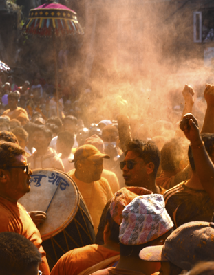
We hardly get any sleep at night. The dining hall next to the dorm is full of trekkers laughing and chatting and as soon as they leave, the porters and guides uncork their bottles of raksi – it’s Dashain and folks are in a festive mood!
We wake up the next morning, bleary eyed and tired, and I have a splitting headache. Anando and Lakpa go off on an acclimatisation walk and I decide to stay back to feast on Namche’s famous cinnamon rolls, and catch up on my reading. In the evening, we spot a shaggy Himalayan tahr clambering up the vegetable patch outside our window and catch a glimpse of an Impeyan pheasant, a fleeting mass of color.
13th October – Namche
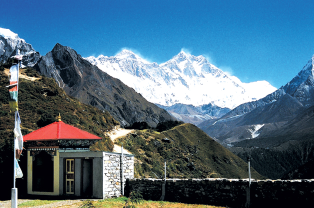
It’s about 8:30 in the morning when we decide to head out for an acclimatisation walk to Syangboche and the Everest Hotel. We circle our hotel and reach a trail that passes a chorten and climb to the top of the ridge overlooking Namche. We walk, rotating prayer wheels, as the snow-covered peak of Kwong De looks down. It’s about nine when we reach the top of the ridge and walk on to the airstrip, which is really a large meadow with Mt. Thamserku on one side and Mt. Khumbhila on the other. We follow a fairly level trail past some meadows to the Japanese-built Everest View Hotel and stop for stunning views of Everest and some very expensive lemon tea. On the way back, we pass through the sprawling town of Khumjung. The Khumjung Gompa is home to a famous yeti scalp (later revealed to be a fake) and yeti enthusiasts are allowed to see and even touch this relic for a small fee.
14th October – Mong La
It is a lovely morning when we leave Namche at about 8:30. Dil hands us his visiting card and we promise to return to the hotel on our journey back from Gokyo.
We follow Lakpa to the centre of town as he trails behind a yak train trying, with a stick, to hurry them along and then climb a ridge to arrive at the trail to Tengboche Monastery. On our way out, we pass the chorten dedicated to the memory of Tenzing Norgay. It is a dazzlingly clear morning and Everest and Lhotse keep us company most of the way. The trail is not steep, but the wind and the altitude mean that we can’t rush it. Lakpa spots a musk deer on the slopes below Namche and we rush over for a glimpse. Anando’s pleased – he manages to catch it on film. At Sanasa, we stop for some steaming lemon tea and browse for Tibetan curios and jewelry while a couple of Englishmen strip to the waist and enjoy the sun.
After Sanasa, Lakpa leads us through the higher, relatively less travelled trail to Gokyo that passes through magnificent pine forests. The forest floor is thick with fallen leaves, red, brown, and gold, and the only sound is that of our feet padding over the fallen leaves. Occasionally, we catch a glimpse of Tengboche on its magnificent perch below Ama Dablam.
We reach Mong at noon. Located on top of a ridge, Mong is probably the windiest point in our journey! We sit outside and watch the sun go down on Ama Dablam and Thamserku. Mong is believed to be the birthplace of Lama Sange Dorje, who brought Buddhism from Tibet into the Khumbhu region.
15th October – Dole
We spend a restless night tossing and turning and are late starting out. The trail descends steeply through a series of sandy switchbacks to the village of Phortse Thenga on the banks of the Bhote Kosi. From here, it climbs steadily up, passing through russet forests of rhododendron, pine, and juniper. We pass a number of kharkas, alpine meadows sometimes used by shepherds for grazing their herds, and a herder’s hut at Tongba, and then climb slowly up to Dole. Lakpa leads us to the rather grandly named Alpine View Cottage, the only place in Dole with no hot shower. After lunch, a troop of German trekkers arrives with a battalion of porters and guides and takes up every conceivable inch of space in the dining hall. We escape outside where a high altitude rodeo is in progress. A yak train has just arrived and the herders are trying to round up the intractable animals, alternatively threatening, wheedling, and coaxing. Soon, the Germans come out and wait loudly for a suitable photo-op.
16th October – Macchermo
We are up quite early and decide to skip breakfast. Lakpa and Jamal are already up and waiting and we leave at around 8:00. We cross the river and hit a steep trail. Ahead a group of trekkers are climbing up at a steady pace and we walk alongside. An affable Australian leads the group and everyone is chatting, swapping jokes, and laughing. Chris, the guide, is delighted to know that we are from Kolkata (formerly Calcutta); he calls it “a fascinating city” and recalls how he had enjoyed spending time at the races, working as a volunteer at Mother Teresa’s, and hanging out at the pubs. Soon, the trail becomes a sandy, level track as we head up into high alpine country. The vegetation changes and prickly scrub juniper and tiny dwarf rhododendrons now replace the birches and rhododendrons that we had spotted earlier. Exhausted and in sore need of refreshment, we stop at Lhabarma for some lemon tea. It has a pretty guesthouse with an outdoor sitting area, sunny dining room, and miracle of miracles, a Western-style toilet! Gaily colored prayer flags flutter in the breeze as we sit outside, sipping our tea. The walk from the next stop, Luza, to Macchermo seems endless. Lakpa gently coaxes us on and at 11:15, just as we are ready to flop down, we pass a chorten on top of a ridge, and there below us, lies the sprawling Macchermo Valley.
We stop for the night at Tashi Dele Lodge, a long, low-roofed building facing the sun. It is neat as a pin, has an indoor toilet (“at least we won’t have to expose ourselves to yeti attacks at night.” says Anando, grinning) and “hot shower facilities”. We are overwhelmingly grateful. Anando complains of a slight headache and after lunch we stroll down to the Porter Rescue Centre to listen to Dr Nick Mason’s talk on altitude sickness. The doctor’s advice to those suffering from AMS – DESCEND! He tells us of a porter who developed AMS in Gokyo and was left behind by his trekking group who went on ahead to the Cho La Pass. The porter was brought back to the rescue centre, where he lay “fighting for his life”.
By evening the lodge is full of trekkers who have traveled here from every corner of the world and we all huddle together in the dining hall, savoring the warmth of the fire and sipping our hot lemons. An atmosphere of easy camaraderie prevails as we swap stories of Nepal, the mountains, Tibetan Buddhism, and local folklore, especially the Yeti. The guides and the porters join in, quietly asserting the Sherpa belief that the “abominable snowman” does, indeed, exist. By the time dinner (dal, bhaat, tarkari) arrives we are all toasty and warm. I have some coffee afterwards, hoping it will cure my headache, and then it’s off to bed. The room is dark and cold as a tomb. We pull out our sleeping bags and down jackets. It’s been a long day!
17th October – Gokyo
In the morning, I’m finally feeling better, but not too confident that I’ll make it to Gokyo. We decide to make it a day trip, go up to the fourth Gokyo lake perhaps, and get back to Macchermo before nightfall. We set off around 7:30 in the morning. On the northern ridge, Chris’ group has already begun their ascent. We go up, very slowly, feeling a little light-headed. From the chorten on top, there is an uninterrupted view of Cho Oyu, so huge that it almost fills up the horizon. Behind us, rises the Kantega, and to the right, a sheer drop overlooks the Bhote Koshi, raging below. Up ahead, everything is barren – just rock and sand. We stop for a minute to allow our breathing to regularize. From here, the trail drops sharply before levelling out and then climbing up again. We arrive at Pangka, and decide to stop for some tea. It was in Pangka that an avalanche in 1995 swept away a Japanese trekking group while they sat resting in their dinner tent. The guides point out the site to the trekkers, and pictures are taken; with time, even tragedy becomes a tourist attraction.
About an hour from Pangka, the trail climbs sharply up, past a cave at Nilibuk. Although the gradient isn’t as steep as what we have experienced earlier, the altitude makes the going difficult. After what seems to be an interminably long climb, we arrive at a steep staircase trail. Above lies Gokyo. At the end of the staircase, is a wooden bridge. The terrain is more or less flat, and a short walk brings us within sight of the dark blue waters of Longponga, the first lake.
At first glance the lake seems almost illusory in this world of hard, uninterrupted grey-brown rock, boulder, and stone. Numerous tiny cairns fashioned out of rocks and pebbles stand up like gravestones around the lake. We have to watch our step, for fear of upsetting one, and inviting the wrath of a mountain spirit.
A rough, relatively level trail leads us to Taujun, the second lake. Here, the water is of a lighter color, an almost solid band of emerald green, defiantly different from the deep azure of the sky. We stop for a while to take pictures.
The trail climbing to Dudh Pokhari, the third lake passes an impressive line-up of high peaks – Cholatse, Gyachung Kang and Kantega, among others. Up on the ridge, on the banks of the third lake, lies Gokyo village. Cho Oyu towers behind the cottages, almost close enough to touch. Here, the water is a lighter blue, and the cheerful smell of cheese omelettes waft in from the lodges above. We stop for breakfast, suddenly realizing that we are ravenous, a good sign in these altitudes. We sit at a table in front of the Gokyo Village Resort, sipping our hot chocolates as the sun sparkles on the light blue waters of Taujun.
From the village, our trail follows a stream for the first few minutes and snakes through scrub pastures where the village herds graze, towards Tonak, the fourth lake. The last leg of the climb is through a landslide-prone stretch sandwiched between two hills. Automobile-sized boulders are scattered all over, and more are perched precariously on the hillsides above one’s head on either side, ready to roll down. Lakpa stops occasionally to look up and sniff the air, making us very nervous. Rather than a pristine mountain sanctuary, this part of Gokyo resembles a construction site from hell.
It’s a long, slow walk up the ridge overlooking the fourth lake. Little cairns continue to dot the hill, marking the trail. We scramble over boulders and scree to arrive at the top. Cho Oyu dramatically dominates the skyline over the frozen, sky-blue, glasslike waters of the fourth lake. To the east, rises the Tolkien-esque shape of an unnamed peak, affectionately called “Nameless Fangs” by trekkers. The Ngazumba, Nepal’s largest glacier, churns its way past the Gyachung Kang and Cholatse Peaks.
This is the point where we turn back. We miss the view of Everest from Gokyo Ri, but after so many magnificent sights, it doesn’t seem like a big sacrifice. And most importantly, it provides us an excuse to turn back.