Muktinath is ageless. It began before the dawn of history as a simple nature shrine. In time its fame spread until it became one of the main destinations on the ‘grand pilgrimage’ of South Asia ...
In 1950 the inveterate British mountaineer, explorer and author H.W. Tilman visited
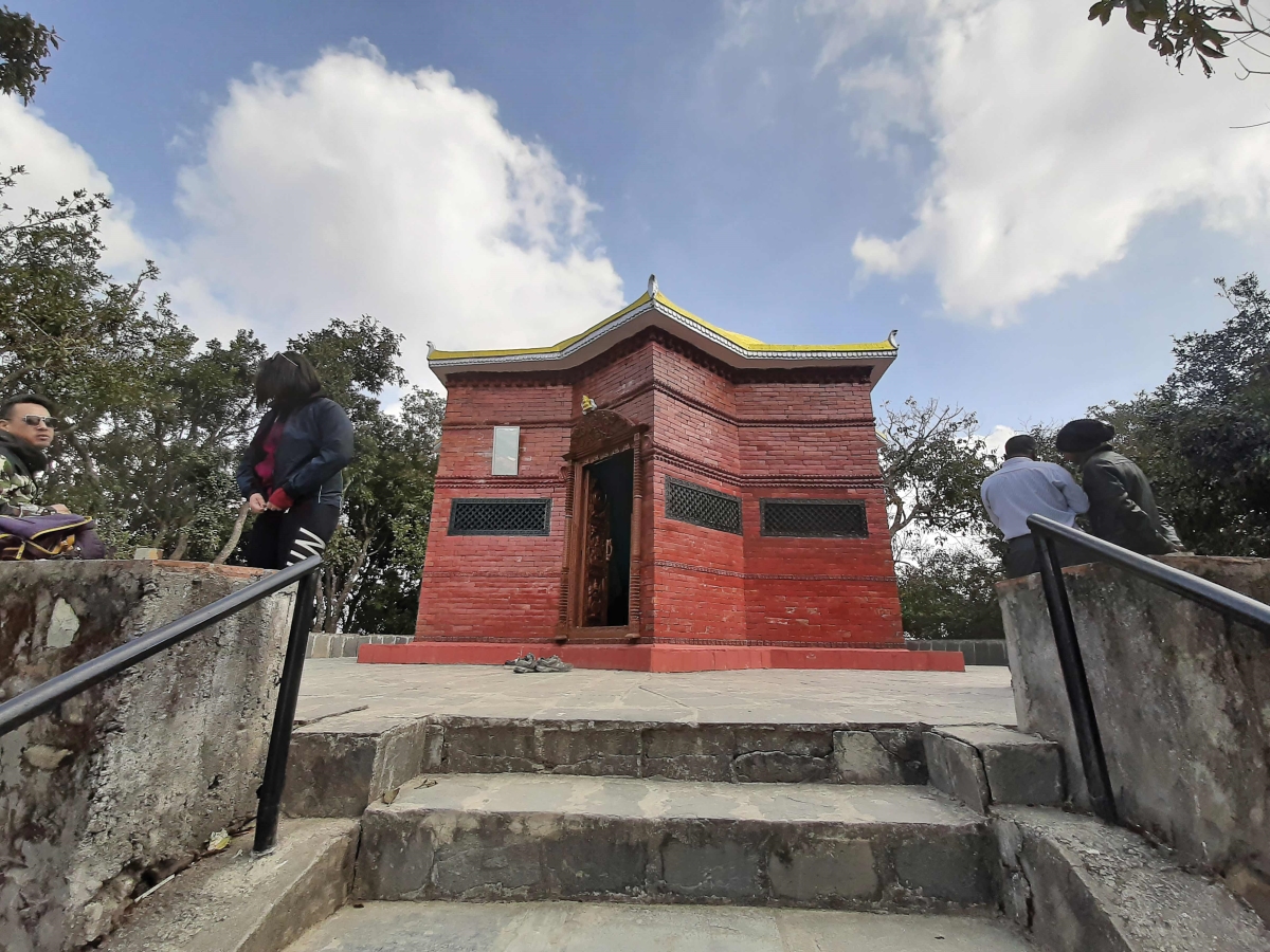
Muktinath, at 13,467 ft in Nepal’s northern Mustang District. In his 1952 book, Nepal Himalaya, he described it as a “celebrated Hindu pilgrim resort..., well watered by springs and streams”. It “owes its sanctity,” he said, “to the presence of the thrice-sacred ‘shaligram’... regarded as emblems of Narayan or Vishnu”.
Tilman was one of the first Westerners to visit Muktinath, though it was already well known by hearsay and reputation among the British in India—and for over 2,000 years before them by Hindu pilgrims. Its earliest name was ‘Salagrama’, after the black ammonite fossils (Tilman’s ‘shaligrams’) found there, far from the bottom of the sea in which they lived millions of years ago. In 1903 Henry Yule and A.C. Burnell described the fossil in their Anglo-Indian dictionary the Hobson-Jobson as “black, hollow, and nearly round; it is found in the Gunduk [Kali Gandaki] River and is considered a representation of Vishnoo... The Shalgramu is the only stone that is naturally divine; all the other stones are rendered sacred by incantations”. Today we call it saligram.
A ‘Super Power Station’
The fossils are avidly collected and worshiped by Hindus, but Muktinath is known for much more. A far deeper objective of each visit is to attain mukti, salvation, through the worship of Vishnu, also known as the Lord of Salvation. A young Brahmin pilgrim from Varanasi (Benaras) once characterized Muktinath to me as “a super power station!”—a place to recharge one’s spiritual (and physical) being.
Foreign trekkers, on the other hand, go to Muktinath to see the magnificent mountain scenery and the austere geological marvels that are exposed in this arid Himalayan uplift zone. It’s many religious shrines, temples and old monasteries are intriguing, as is the Tibetan borderland culture that can be seen in the villages. Some may find religious solace there, too. For the most adventuresome, such as those doing the popular Annapurna Circuit trek, Muktinath is the welcome first stop after coming down the mountain from the 17,770 ft Thorung Pass that separates Manang District (at the east) from Mustang.
Muktinath is ageless. It began before the dawn of history as a simple nature shrine. In time its fame spread until it became one of the main destinations on the ‘grand pilgrimage’ of South Asia, described in the epic Mahabharata (c.300 BC) and in the historic Purans (300-1000 AD). Today, Muktinath ranks alongside such other ancient mountain-and-water sites Kedarnath and Badrinath in north India, the Amarnath ice cave in Kashmir; and Mount Kailash and Lake Manasarowar in western Tibet. In Nepal it is comparable in sanctity to Pashupatinath in Kathmandu and the sacred lake of Gosain Kunda north of Kathmandu in Langtang Himal.
Last winter I visited Muktinath with two friends, Kyle and Narendra. Kyle is a Canadian and was brand new to Nepal. Narendra lives here. Together, we saw Tilman’s springs and streams and searched for fossils, but we found no ‘resort’ in the modern sense of a holiday dream destination. Tilman used the term in its generic meaning of a popular place frequented for a particular purpose. Until recently, that purpose was primarily religious. We also saw Muktinath’s famed 108 water spigots all in a row, where pilgrims bathe their sins away. Because it was winter and we arrived in a blizzard, there were no pilgrims. We met only the lonely fellow who registers visitors and takes donations (100 rupees will do), one of the Nyingmapa Buddhist nuns responsible for maintaining the religious sites, and three uniformed policemen huddled around a brazier of hot coals playing cards. Everyone was intent on keeping warm.
I told Kyle that zealous pilgrims typically ‘run the gauntlet’, so to speak, by bathing under all 108 of the cold water spouts; women in saris, men in their loincloths. A few moments later while I was fiddling with my camera, I heard a whoop and a holler, and turned in time to see Kyle—not one to avoid a challenge—streaking by under the spigots in his undershorts. He was young and up to the icy challenge, but Narendra and I declined the honor.
That afternoon we met two European trekking parties descending from Thorung pass. They had been hiking since 4 o’clock in the morning through deep snow in near blizzard conditions. They looked cold, dazed and exhausted. Crossing these mountains is difficult and dangerous in any season, but is definitely not advised in the dead of winter. Just that morning a helicopter had arrived to medivac a foreign trekker with severe frostbite from her ordeal on the pass the day before.
Nobody is likely to get frostbite at Muktinath even in the worst weather. We found it cold, virtually deserted and lonely, but not hazardous. A winter trek to Muktinath is certainly doable, but unquestionably unique; something to write home about. In warmer seasons this complex of shrines, temples and other holy sites is typically swarming with worshippers from all over South Asia. They hike up from the lowlands at such auspicious times as Janai Purnima in August, Krishna Asthami in September and Chhait Dasain in April, to name a few. In some years, two festivals, one sacred and one secular, coincide in August creating a great spectacle of two cultures mixing. When the local horse racing festival of Yartung occurs (every few years) on the full moon day (purnima), visitors can see pious Brahmins bathing at the shrine and changing their sacred cord (janai), which signifies their ‘twice-born’ status, while the locals are enjoying the races fifteen minutes down the mountain at Rani Pauwa.
Muktinath’s Natural Wonders
The natural wonders of the place are special, and the three of us were determined to see them. The most important of them are the copious springs, several natural gas vents burning in the ground, and the numerous saligram fossils. Pilgrims consider them all to be ‘mysterious signs’ sent from the gods. Human Culture has interpreted and modified Nature here to create a place of super-natural awe and wonder, far removed from the mundane world of daily life.
The springs of Muktinath, I told Kyle, are said to be directly (though inexplicably) connected to Lake Manasarowar. Springs, lakes, river sources, fords and confluences are all ‘sin-destroying localities’ to Hindus. We found where the springs seep from the rocky hillside above the main temple, the Vishnu Mandir, then are neatly channeled into the 108 spouts shaped in the form of bulls’ heads. Tibetans call Muktinath Chumig Gyatsa, ‘the place of 100-odd springs’. The number 108 represents the number of books of Tibetan Buddhist scripture and beads on a Buddhist rosary. Bathing is a meritorious act and focal point of every pilgrim’s trip to Muktinath. Most pilgrims face the icy spigots straight on, while others scrub up vigorously, head to toe, in a flurry of soapsuds, then dash along under all of the 108 spigots to rinse off. Less zealous visitors simply take a sip of the sacred water at the first spout and sprinkle a little over their head.
We asked the Buddhist nun to show us the natural gas fires burning under the altar in the temple of Jwala Mai. She agreed after we said we’d contribute something to the temple’s upkeep. First, however, Kyle strung some prayer flags up in the trees near the shrine, pausing for a moment in silence to remember his grandfather who had told him stories about trekking in the Himalayas a quarter of a century earlier. Then we walked eight minutes or so south across the temple complex to Jwala Mai through fresh fallen snow. (It is said to be 108 fathoms distance from the Vishnu Mandir.) Originally, the fires burned from the earth, from a small spring, and out of a stone. After touring the site in 1956, the Tibetologist David Snellgrove wrote, in Himalayan Pilgrimage, that “The flames of natural gas burn in little caves at floor level in the far right-hand corner [of the temple]. One does indeed burn from earth; one burns just beside a little spring (‘from water’); and one ‘from stone’ exhausted itself... [in 1954] and so burns no longer, at which local people express concern.”Kyle is a forest fire smoke jumper in his other life, and he wondered about the significance of fire here. I explained that fire is one of the most important elements in Hindu Vedic ritual. For a moment he was confused, since these fires were enshrined inside a Buddhist temple. At Muktinath and throughout Nepal, I told him, there is a profoundly syncretic relationship between these two religions (a refreshing fact, we all agreed, given so much religious strife elsewhere in the world). For some, Buddhism is a branch of Hinduism, an opinion about which Buddhists appear to be quite tolerant. Furthermore, for every Hindu deity at the shrine there is a Buddhist equivalent. For example, Lamaist Buddhists call Vishnu ‘Lokeswar’ (Avalokiteshvara), the protective deity of the Tibetan nation (incarnate as the Dalai Lama).
Fire, I went on, is represented by the fire-god Agni and is the object of much mysticism and speculation. Agni’s presence ensures communication between humans and gods. Fire is central to the ritual acts of possessing a territory and during the creation of a sacred place of worship. Part of the ‘miracle’ of this mukti chhetra, or ‘salvation place’, is the belief that the fires were a gift from Lord Brahma who is said to have made offering by setting the water alight. Geologically, the gas vents emanate from the same shales in which fossils are found.
Finding some black ammonites were our third nature quest. We searched for them in the Kali Gandaki river bed but determined that we would have better luck in summer or fall, when the river is fuller and washes new (old) fossils out of its banks. Pilgrims believe the fossils to be a sure sign of Vishnu’s presence. Saligrams are the remnants of an extinct form of cephalopod mollusk with a coiled, flat chambered shell. They lived in and left their remains under the prehistoric Sea of Tethys that existed before the slow continental collision that created the Himalayan uplift that gradually joined the Indian subcontinent to Tibet. According to geologists the Muktinath ammonites date from 140 to 165 million years ago. They are also found in north India and southern Tibet, but those around Muktinath are particularly abundant, well preserved and relatively easy to find.
Before we left the Vishnu Mandir, we saw a stone pillar said to have been erected by Jang Bahadur Rana in the 19th century. Narendra interpreted the inscription on it, to the effect that breaking open the fossils is (or was, in those days) punishable by having your hands cut off! Regardless of his ruling, saligrams are for sale, both whole and broken, at Muktinath and Jomsom, Pokhara and Kathmandu, by two-handed shopkeepers.
Getting There
There are two ways to go to Muktinath: walk or fly. Either way, the visitor passes through some of the most spectacular mountain scenery on Mother Earth.
We got there the old fashioned way, by walking the pilgrim trail. There are two routes, one via Naya Pul to which the trekker can go by bus or taxi from Pokhara on the Baglung road. The trail then passes through Birethanti and ascends the Bhurundi river valley for two days, topping out at Ghorepani Pass (9,022 ft). For the ornithologically inclined, the oak and rhododendron forests on either side of the pass provide some of Nepal’s best mountain birding. The walk from the hotels at the pass to the top of nearby Poon Hill (10,475 ft) is also popular, especially for early morning panoramic views of the Dhaulagiri and Annapurna massifs. Bring plenty of film or digital memory for your camera.
The alternate walking route, which we took, starts north of Baglung, out of the Myagdi District town of Beni or from nearby Galeshwor, the site of another prominent pilgrims’ shrine dedicated to Lord Shiva. North of Galeshwor we walked along the new road being built beside the Kali Gandaki river up into Mustang District. The riverside road and the Ghorepani trail converge at Tato Pani hot springs, a popular stop for those who prefer a really hot bath over a really cold one of Muktinath.
It took us four days to reach Jomsom in Thak Khola, as the upper Kali Gandaki river valley is called. During those days we ascended over 5,000 feet, from 3,838 ft at Galeshwor to 8,890 ft at Jomsom, with overnight stops in Tato Pani, Ghasa and Tukche.
The Kali Gandaki Gorge
Several hours walk above Tato Pani, we stopped for lunch in Dana, noted for its delicious suntala oranges in season. Then, trekking upward and onward towards Ghasa, we passed through the most dramatic part of the Kali Gandaki gorge. On our way, the view of the Rukse Chhahara waterfall was stunning, and seeing raptors (especially eagles and vultures) soaring below us high over the roaring river was awesome. It reminded us how high we were now climbing, relatively speaking, though we were still far below the surrounding peaks. While ascending the eastern side of the gorge, we looked west across west at the sheer cliffs on the opposite side where we could make out the original pilgrim track (long abandoned). In places it looks very dangerous. We were glad to be on the newer, wider, safer trekking trail.
The steepness and deepness of the Kali Gandaki gorge here provides some of the world’s most astounding geological entertainment. Consider this: If you draw an imaginary line from Dhaulagiri-I (26,794 ft) directly east over Ghasa you’ll hit Annapurna South (23,684 ft), a younger sister to nearby Annapurna-I (26,545 ft). Your make-believe line will be 15 miles long, peak to peak, representing the broadest width of the gorge. The average height between the two peaks along that invisible line is 25,239 ft. The elevation of Ghasa is only 6,595 ft, so the depth of the gorge here is a staggering 18,644 ft (approximate). That’s over three and a half miles or almost 6 kilometers deep! It is so deep and so steep, in fact, that you can’t see the peaks until you emerge from the forest above Ghasa at Lete; and then the highest of them are south, behind you.
Thak Khola
By the time we reached Lete, we were well within the rain shadow north of Dhaulagiri, in Thak Khola proper. This is the home of the Thakali people, renowned for their trading skills as well as their remarkable cuisine. It is still dal-bhat-thakari, the staple rice, lentils and veggies, but sooo much better than what is available anywhere else on the trail. And all about us now were snow capped and glaciated mountains, including the east Dhaulagiri icefall hanging directly above the town.
The road from Galeshwor to Ghasa was not yet finished, but from Ghasa the track was passable to motorcycles and small tractors. We turned down offers by motorcycle-walas to pay for rides the rest of the way to Jomsom, and later from Jomsom to Muktinath. That’s no way to travel! It’s noisy and polluting, and while roaring along the bumpy track the rider misses the ‘feel’ of the land, the people and the culture. There is talk of opening up a new path on the west side of Thak Khola, one that avoids the road altogether and retains the spirit of trekking. A great idea!
There are many places to stay in the towns of Thak Khola. Hotels and guesthouses come in all grades, from cheap to expensive, and the hospitality is superb.
We spent one night at an inn in Tukche. During the first half of the 20th century this town was a major trade center to which Tibetan traders brought salt by yak trains down from western plateau to exchange for rice carried up on the backs of stalwart porters from Nepal’s mid-hills. The Thakalis were the middlemen in this trans-Himalayan exchange. This is also apple country, and we enjoyed the local fruit sliced up raw in our morning porridge, as jam on our Tibetan breads for lunch, in apple pies (sans ice cream) for dessert, and as apple brandy for a nightcap. At Jomsom, we did the mandatory check-in at the police post, and registered our trekking permits with the local office of the Annapurna Conservation Area. Fee permits can be purchased in Kathmandu (at half the price that they cost if you wait to buy them in Jomsom.) The registration process was repeated at the police post two days later at Rani Pauwa, the last stop before Muktinath.
At Jomsom, we stayed in the upscale Om’s Home hotel, primarily because the owner, Vishnu Hirachan, is an old friend. We also made use of the town’s cyber café, to send messages out to family and friends about our adventures so far.
The walk from Jomsom up to Muktinath goes through two small towns. The first is Eklai Bhatti, a few hours upriver, a relatively new settlement primarily of guesthouses and eateries for trekkers. Kagbeni is further along, a more ancient village strategically located at the confluence of the Jhong (Muktinath) and Kali Gandaki rivers. The confluence, called a beni in Nepali, is a sacred site where Hindus perform shraddha, a special puja in honor of deceased family members. In the past, Kagbeni (also called Kag in Tibetan, meaning ‘blockade’) controlled access and collected tribute from traders coming and going on trade routes that go off in the four cardinal directions. To the north, towards Tibet, is upper Mustang, a restricted area. Entry for foreigners requires buying an expensive permit in Kathmandu and outfitting with guide, porters, cooks and horses. To the west is the remote district of Dolpa. To the south is Jomsom and the rest of Thak Khola, and the way down through the middle hills to Pokhara. At the east is the trail to Muktinath and beyond, over Thorung Pass into Manang.
At Kagbeni, we checked into the Red House lodge, the oldest guesthouse in town. There are many fine hotels here, but the Red House has the most intriguing history (and it really is red). It started out as the home of the town’s old aristocracy. Then, during the 1960s and early 1970s, it was a safe haven and hang-out for Khampa guerillas waging a protracted insurgency across the border in Tibet. The matron of the lodge and her son regaled us with many stories from the past.
Shortly after we arrived we noticed a newly made zig-zag trail up the steep mountainside to the west, across the river. The lodge owner told us that she and the town’s other hoteliers had constructed it for the convenience of trekkers who want to see into upper Mustang, but who do not have the expensive permit to go beyond the town’s northern gate. We climbed the mountain, two hours steeply up to the 14,000 foot viewpoint, and one hour back down. The results were a spectacular view from the top into upper Mustang and straight down on to the roofs of Kagbeni, as well as the discovery of a few small fragile fossils in shale alongside the track, and stiff knees and sore thigh muscles from the precipitous descent. When we arrived back at the lodge, just before dinner, we were ceremoniously greeted by the owner who garlanded us with silk khata scarves in honor of the fact that we were the first foreigners to climb the new trail too the lookout.
The next day we completed our trek to Muktinath, doing and seeing all the wonders of the place with which this story begins. That night we stayed in a rather crusty hotel in the old village of Dzarkot, about an hour below Muktinath. The following day we trekked back down to Jomsom, bucking a stiff wind on the river trail. Kyle and Narendra then walked back out to Pokhara via the Ghorepani trail, and I flew out on one of the regular daily flights to Pokhara.
Will I do it again? Of course. It is one of Nepal’s premier treks. This was my twelfth trip, and each time I have seen and learned new things. It is a great adventure for trekkers and pilgrims alike.
Don Messerschmidt is the new associate editor of ECS magazine, a writer and anthropologist. He first came to Nepal in 1963 and has worked here since then in various capacities on development projects, conducting research, writing and editing. He is the author of a little book called Muktinath: Himalayan Pilgrimage, A Cultural and Historical Guide (1992), several shorter works on Himalayan pilgrimage, and books and articles on many other subjects.
Some lesser-known vegetable dishes from the southern plains
I’m not a vegetarian but I love vegetables. And whenever I get to the southern plains of Nepal, I try...